Cycling in Thailand - General Info
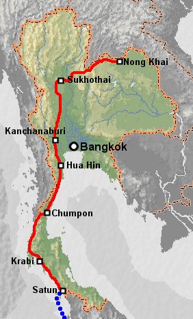 We
were in Thailand from the 6th of June to the 24th of September. After a two
week "holiday" without the bikes we pedalled from Nong Khai (opposite
Vientiane in Laos) west to Pitsanalok and then Sukhothai, then south through
Kanchanaburi and down the penisular to Chumpon. At Chumpon we crossed to the
west coast and went south to Satun where we took a ferry to Langkawi in Malaysia
(thus avoiding the four troubled states). We visited Bangkok without the bikes
but gave it a wide berth when we were riding. I think the best riding was from
Nong Khai westwards along the Mekong.
We
were in Thailand from the 6th of June to the 24th of September. After a two
week "holiday" without the bikes we pedalled from Nong Khai (opposite
Vientiane in Laos) west to Pitsanalok and then Sukhothai, then south through
Kanchanaburi and down the penisular to Chumpon. At Chumpon we crossed to the
west coast and went south to Satun where we took a ferry to Langkawi in Malaysia
(thus avoiding the four troubled states). We visited Bangkok without the bikes
but gave it a wide berth when we were riding. I think the best riding was from
Nong Khai westwards along the Mekong.
Thailand suffers a little from excessive traffic. Particualarly in the south
there are not many roads to choose from and most them are quite busy. However
almost all roads have wide shoulders for bicycles and mopeds so even the busiest
roads are not dangerous, just noisy. On the positive side, the people are friendly,
many of them know a little English, there is a huge range of tourist attractions,
and the food is excellent. Without camping, budget a minimum of $10-$15 a day
for a couple cycle touring.
Red tape
We obtained our Thai visas from the Royal Thai Consulate, near the Kunming
Hotel in Kunming, Yunnan, China. It is a few minutes walk from the Camelia Hotel
where the Lao Consulate is. For 200Y (about $25) each we got 60 day "non-immigrant"
visas in 24 hours. The visas were valid for entry within three months of issue.
This visa is extendible for another 30 or maybe even 45 days. We were told at
the Nong Khai immigration office that they can only be extended within five
days of expiry, but in Kanchanburi the immigration office extended them by 30
days even though they still had thirteen days to run (the extension was from
the date of expiry, not the date of extension, so we had a full 90 days in Thailand).
The fee is 1900 baht (almost $50).
30 day visas are available free at all border crossings, but these cannot be
extended. When our ninety days were almost up we made a day trip from Ranong to Myanmar in order to be issued a fresh 30 day visa on re-entry.
Although there were signs forbidding cyclists, no one objected to us pedalling
across the Friendship Bridge. Cyclists we met who had come from Thailand said
they were told to take a bus, but the bus driver refused them so they were allowed
to cycle. On a Sunday afternoon there was almost no traffic. There was a 5000
kip (50c) exit tax at the bridge.
We left by ferry from Satun to Langkawi and thence to Penang. The bikes went
free and the ferry people were helpful.
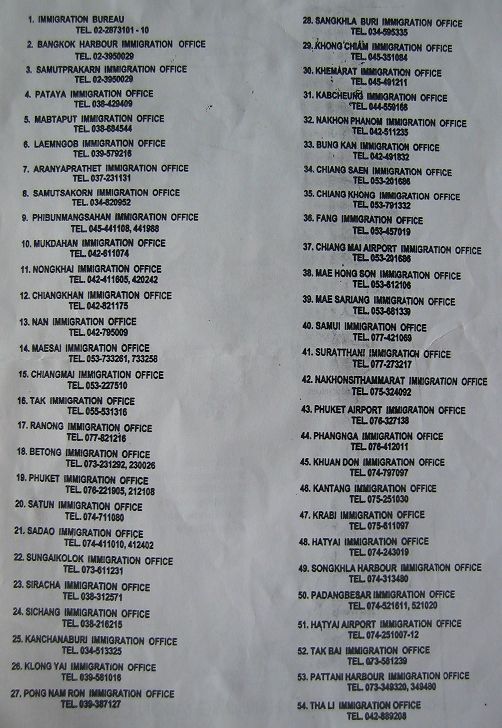
Click here to see a scan of a complete
list of Thai Immigration Offices (96kb).
Bike shops
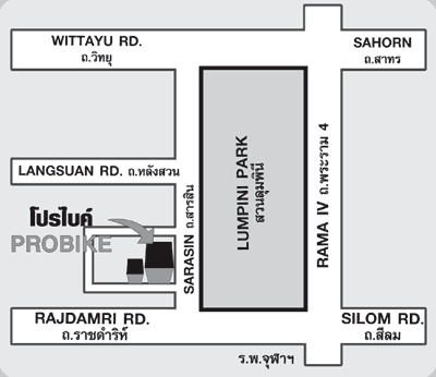
In Bankok "Probike" has a wide range of bikes, spares and accessories.
It is mostly mountain bike and racing equipment but there are some reasonable
tyres, panniers and racks, etc. The staff speak good English. The address is:
237/2 Sarasin Rd, Lumpinee Park, Bankok 10330, Tel 02 254 1077. It is about
200m east of the NW corner of Lumpinee Park, which is a couple of kilometers
east of the main train station. See map below:
In Phitsanalok Probike is near the Tesco-Lotus centre, tel 055 220155. Coming
into town from the east on highway 12, turn left at traffic lights about 200m
before the Tesco-Lotus centre (big signs easily visible from the turn). Go about
200m down this road and the shop is on your left. They have a range of mountain
bike parts, Shimano components, etc.
In Ranong there is a small but surprisingly well stocked Probike about 100m
east of the hospital on Thanon Kamlangsap.
I am told that there are also Probike shops in Chaing Mai, Chaing Rai, Koh
Samui, Lampang and probably many other places.
All towns have bicycle shops, often well stocked with basic spares for mountain
bikes.
Maps and guides
Thailand was the first country we visited where guidebooks where readily available.
For example in Nong Khai there is a bookshop near the Mutmee guesthouse which
stocks Lonely Planet guides and phrasebooks for all the countries of South East
Asia. In Bankok we purchased three maps in a series by "PN Map" (www.pnmapthaipanit.com)
which cover the whole country in four maps at a scale of 1:750,000 and have
contours. They are far superior in detail and accuracy to the Lonely Planet
Atlas, although the accuracy of the depiction of minor roads is still poor.
PN Map also publish a 1:1,200,000 scale map of the whole of Thailand on a single
double-sided sheet. This map is identical to the 1:750,000 series but photographically
reduced. Thus it is lighter to carry but harder to read!
Accomodation and camping
After China there, accomodation was less frequent and more expensive, but camping
was easier. Not all towns have hotels. Away from touristy areas the hotels cater
to Thai business people and never cost less than $5, often $10. The standard
is good, always en-suite and often with air-con. In areas frequented by western
tourists there are often more basic hotels which can cost as little as $3. We
camped quite often, either on field margins or grazing land, or by the sea.
Virtually all National Parks have camping facilites which are often free once
you have paid the park entrance fee. In the wet season it can be hard to dry
the tent and damp items go mouldy very quickly. For this reason and because
of the unpleasantness of camping on soggy ground in the rain, we tried only
to camp when the weather was good.
Away from touristy areas hotel signs are often in Thai only. We spotted the
following:

Mobile phone info
There are three main mobile phone companies in Thailand: Orange, DTAC / HappyDprompt
and AIS. Orange have pretty poor coverage in rural areas with even some small
towns having no coverage, DTAC is better and AIS is I think the best. I tried
Orange and DTAC pay as you go SIM cards, each costing about 200B. The main disappointment
was that their data services only gave access to web sites, not the internet
and not our mail server. So I had to get an account with a Thai ISP (CSLoxInfo,
12 hours online for about 150B from any 7-11 shop) and then ring that with the
mobile at a cost of 5B/min. Still, internet cafe charges in some parts of Thailand
were 60B/hour or even 120B/hour on Koh Tao so it was worthwhile. I think AIS
do a GPRS internet service but it is 1000B for the SIM card and you may need
a contract.
DTAC GPRS settings:
APN: wap.djuice.co.th
Username: <blank>
Password: <blank>
WAP gateway: 203.155.200.133
Medical and dental treatment
Basic Thai medical facilities seem to be of a high standard but inexpensive.
For example Mark visited the emergency room of Nong Khai hospital with a high
fever. He was seen within fifteen minutes, diagnosed as having bacterial diarrhoea
and given three different drugs (antibiotics, anti-nausea and rehydration mixture),
all for $1.50!
We also visited the dentist in Nong Khai for a check-up which unfortunately
led to a few fillings (all those Mars bars...). The check up was free and fillings
were $12 each which is a lot cheaper than unsubsidised care in the west. This
was a small clinic near the central bus station.
Route and accomodation details
Nong Khai to Sukhothai
From Nong Khai we pedalled via Ban Phu to the Phu Phrabat Historical Park (see
diary). There were bungalows here for 300B and camping for 20B/person. Next
we headed north back to the Mekong and Sangkhon and then west to Pak Chom and
then Chiang Khan. From there we went to Dan Sai, stopping en route at the small
village of Ban Pak Huai (stay in rickety bamboo bungalows or hang your mosquito
net under riverside shelters by the restaurant). Then to Dan Sai which has a
guesthouse on the west side of the river, near the T junction with highway 2113.
We also stopped in Nakkon Thai which has a guesthouse about 1km out of town
on the road to Chat Trakan. In Phitsanulok (decent bikeshop see above) your
guide book will list many places to stay but we found cheap places to stay without
going into the centre by following an English sign off highway 12 to the "Bus
terminal", about 1km west of the Tesco-Lotus centre, 1km east of the railway
lines. Near the bus terminal are several 150B/night places. In Sukhothai we
really liked the "No.4 guesthouse" with shady bungalows, the perfect
place for an afternoon spent rebuilding wheels!
This route from Nong Khai to Pitsanalok was very scenic and traffic was light
until we joined highway 12. In places there were very steep hills but until
Dan Sai they were never more than a hundred meters high. From Dan Sai to Nakkon
Thai the hills were bigger but less steep, once on highway 12 it was pretty
flat.
Sukhothai to Kanchanaburi
The road south from Sukhothai to Kampheng Phet was surprisingly busy. We spent
a day in the "Teak Tree Guesthouse" in Kampheng Phet (see LP guide)
but didn't bother to visit the ruins as we had seen something of them on the
way into the town and they looked similar to those at Sukhothai. From Kampheng
Phet the traffic remained with us even though a big highway ran parallel to
the road we took along the river to Khanu Woralaksaburi. There were three guesthouses
on the road linking Khanu Woralaksaburi to the highway. Once across the highway
and heading for Lat Yao the traffic dropped away and the road was really pleasant.
We took a shortcut on a partly dirt road that led through tobacco plantations.
In Lat Yao we found a guesthouse (200 Baht) about 1km from the centre on the
righthand side of the Nakhon Sawan road. Continuing to Uthai Thani the traffic
remainded light until we met highway 3220 coming in from Krok Phra.
Uthai Thani has a couple of hotels costing around 300B per night. From there
we rode south to Han Kha (guesthouse by bus station and another about 1.5km
north of the town) and then west to Dan Chang (expensive hotel 1km east of the
town, 200B per night guesthouse 100m west of the main crossroads with highway
333). Even the PN Map left something to be desired in the region of Han Kha,
you will have to ask the way! From Dan Chang we went south-west to Nong Pru
which did not appear to exist, then south to Bo Phloi (very expensive golf resort
5km north of town, standard looking guesthouse in the town), and then to Kanchanaburi.
Kanchanaburi to Hua Hin
From Kanchanaburi we headed south to Chom Bung (500B hotel in the Rajabhat
Institute, we camped about 10km west of town in a tobacco plantation) and then
via Ban Kha to Nong Ya Plong. Approximately 30km south of Ban Kha is a comfortabel
300B per night hotel in the middle of nowhere. It is exactly 550m NW of the
junction between highways 3206 and 3337. We were told that Nong Ya Plong also
had accomodation but we didn't see it. 20km south of Nong Ya Plong we stopped
at the "House of God Resort" (see diary)
where we were fed a vegetarian meal and allowed to camp in front of the Wat,
all for free! From there we went to Kaeng Krachan (plenty of accomodation from
500B, or camp by the park headquarters, I don't think you need to pay the entrance
fee to camp) and then to Hua Hin on the coast.
Much of this section was on third class roads which were usually but not always
surfaced. Signposts were rare, but a new road is being built along the whole
route so that will make navigation easier. Traffic was mostly light. It was
mildly hilly and quite scenic.
Hua Hin to Chumpon
www.mrpumpy.net also has a good description
of this section, and there is a Dutch book available which details how to ride
the coast without going on the highway more than absolutely necessary. There
are more alternatives than even the 750,000:1 PN map shows, but navigation is
tricky. Highway 4 is more unpleasant than dangerous as it has a wide shoulder
for bicycles and mopeds.
We left Hua Hin on the highway and turned off it at Ban Khao Tao to visit the
Pranburi Forest Park and its excellent Mangrove Nature Trail (no charge, camping possible). From
the Nature Trail we rode directly to the Sam Roi Yot National Park (no need to pay entrance if you are only riding through the park, Hat Sam Phraya
is the nicest place to camp) before rejoining highway 4 at Kui Buri. We later
discovered that it is possible to delay joining the highway until Ban Bo Nok,
about 10km further south. From there we rode to Prachuap Khiri Khan down the
highway, although it is possible to leave the highway about 15km before Prachuap.
From Prachuap Khiri Khan there is no choice but to ride the main road south
for around 50km. We left the highway down road 3459 to Ban Krut. There is no
sign in English or road number. Ask for Ban Krut. Although the map does not
show it, there is a paved road down the coast joining Ban Krut with Bang Saphan.
There are reasonably priced bungalows along this road. The coast road south
is then clear on the map through a network of roads to Chumphon. There are few
signs, but just ask for Chumphon. About 15km before Chumpon is the Chumpon Cabana
resort and several other much cheaper places to stay. There is snorkelling on
the rocks near the Cabana, we saw a cuttlefish and many other things.
Chumpon to Krabi
Although it is still called highway 4, the road becomes a lot quieter west
of Chumpon. The hills are very gentle and only 70m high. There is bungalow accomodation
about 1km south of Kra Buri for 250-300B. The hills are actually slightly bigger
heading south to Ranong, but still pretty gentle.
Ranong is an interesting town with lots of Burmese and Chinese influence. Accomodation
and internet access is cheap. The visa run to Myanmar makes an enjoyable half
day out, it is about half an hour on the boat with plenty to see. Everything
was very straightforward for us, we paid 200B for a boat to take the two of
us across and back, plus $5 each to Myanmar immigration.
The hot springs by Ranong were a real disappointment, those in the wat were
closed and the spa was expensive and characterless (they may be building something
else though, there were half built pools in August 2004). But 9km south of Ranong
(about km 621) we saw a sign to "Pornrang Hot Spring". We went 1km
east along a side road and then another 1.5km up a steep stony track that ended
in a small parking area. Across a bridge were concrete vats of warm and hot
water and a swimming pool that unfortunately was slightly too hot (45°C)
for swimming. Just the thing for washing off the road grime.
About 48km south of Ranong in the village of Ban Samnak (by the turn-off to
Laem Son National Park) we found homestay accomodation for 300B total including
a tasty evening meal. There is also bungalow accomodation on the beach by Laem
Son National Park, 10km west of the highway. 70km further south there are several
hotels in Khura Buri, "Tanarin Riverhuts" was good at 250B. About
1km north of Takua Pa is a tidy Thai hotel at 500B a night, in the town the
"Extra Hotel" (photos of the enticingly clad "extras" are
pinned to the Coffee Shop door) has rooms from 200B.
We took road 4032/4090 south from Takau Pa, it was pleasantly quiet and scenic
until we joined highway 4 again, 7km north of Phang Nga. We went to Phrang Nga
because that was the nearest accomodation but stronger riders could head east
through Thap Put (no accomodation) to Ao Luk (see below). In Phrang Nga there
are many hotels, the Thawisuk is a cheap decent hotel with wheel-in bicycle
access. From Phrang Nga we followed the busy but scenic highway 415 east through
Thap Put. 5km east of Thap Put we took a minor road south to Ao Luk. There is
no accomodation in Ao Luk itself but a couple of kilometers north of the town
(1.5km south of highway 4) there are bungalows for 200B by Than Bokkharani National
Park. There is also a smart looking Thai hotel near km 141 on highway 4, about
37km from Krabi, probably around 400B/night. Our next stop was Ao Nang, note
that it is by 'Ao Nang bay' on the LP map, not where Ban Ao Nang is marked,
also that it is called Ao Phra Nang on many signs.
Krabi to Satun
Between Krabi and Klong Thom we passed three places to stay (guesthouses and
bungalows), they were at km 76, km 83 and km 89 (that is 4, 11, 17km north west
from Klong Thom). There is also a hotel in Klong Thom, they wanted 350B for
a fan room. We went 10km east from Klong Thom to the "Hot Stream" (admission
90B) where nobody seemed to mind us camping in a pagoda by the stream. Take
a mosquito net and enjoy the hot bath!
South from Klong Thom we saw no hotels until Trang or Pak Meng beach. But the
Ang Thong falls would be a great place to bivy (no one about and a nice shelter
to hang your mosquito net in) as long as it doesn't rain too much. When we stopped
by after a night of very heavy rain, the pagoda floor was underwater.
Leaving Trang by highway 4, then 404, then 416, we passed the Thung Kai Resort
Hotel after 12km. There is supposed to be a hotel in Yan TaKhao at 30 Yot Prasat
Rd, but we didn't see it (or look for it). The next place to stop is the Green
House Resort in Thung Wa, we got a slightly shabby air-con room for 360B (there
was nothing cheaper). This is exactly halfway between Trang and Satun. 25km
further on (about 50km from Satun) we saw "Marimar Bangkalo" by the
turn off for Langu. There is also accomodation at Langu from about 200B. The
road was scenic but with quite a lot of traffic.
From Satun we took the ferry to Langkawi. They run almost hourly and take bikes
with no fuss (you need to unload the bike and carry it on, have some string
handy to tie it down). There is money change in the terminal.
|
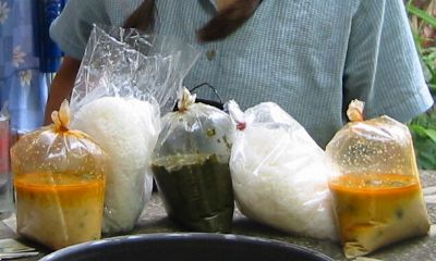
Takeaway curry, Thai style!
|
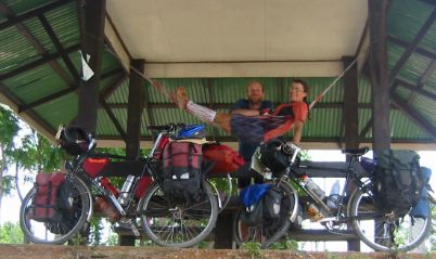
Many roads have shady bus shelters.
|
Home Country info index
Thailand diary Printer friendly version