We had a lot of trouble finding out if this route was even possible, so we thought others might find this information useful. You can get maps of Altai in Novosibirsk at the Central House of Books, on Krasny Prospekt near Ploshchad Lenina. The only map of Tuva we had was our road atlas, which was wildly inaccurate regarding the passability of the roads and tracks.
We registered our visas in Gorno Altaisk (see the Russia page) and obtained a "proposk" from the military base in Aktash, near Kosh Agach. Theoretically there may be some need for a permit for the Tuvan part of the route which would be issued in Kyzyl. The only soldier we met in the mountains was extremely friendly, helpful and even took a photo of "the English cycle tourists". He did not check our passports, visas or permits. Likewise another soldier we met at the cafe on the Arzaiti Pass gave us useful advice regarding the track to Ak Douvrak, invited us to visit him in the police post when we got to the asphalt road and did not check any of our papers.
The whole route is between 2000m and 2500m, so you must be prepared for bad weather at any time of the year. We were hailed on and had thunderstorms most afternoons. When we were near Sagly it snowed down to 2000m, and this was in August!
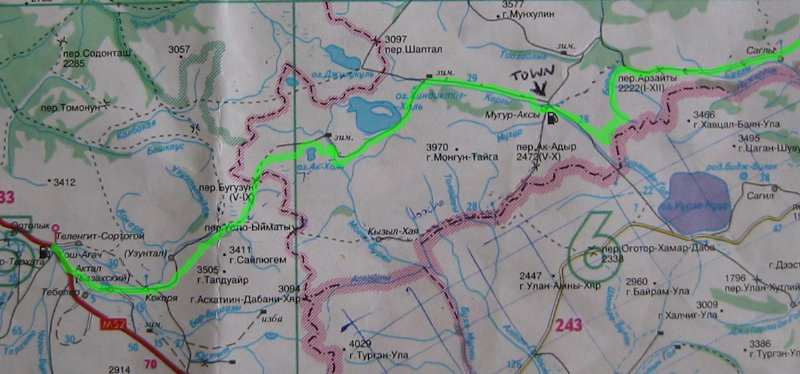
From Kosh Agach follow the Chusky Tract road (M52) south-east to the signed turnoff for Kokorya. The Kokorya road is asphalt. Go into the village of Kokorya (watch out for the dogs) and keep straight on to the back of the village where there is some kind of municipal building. To the right of this building a track leads up the valley, follow it.
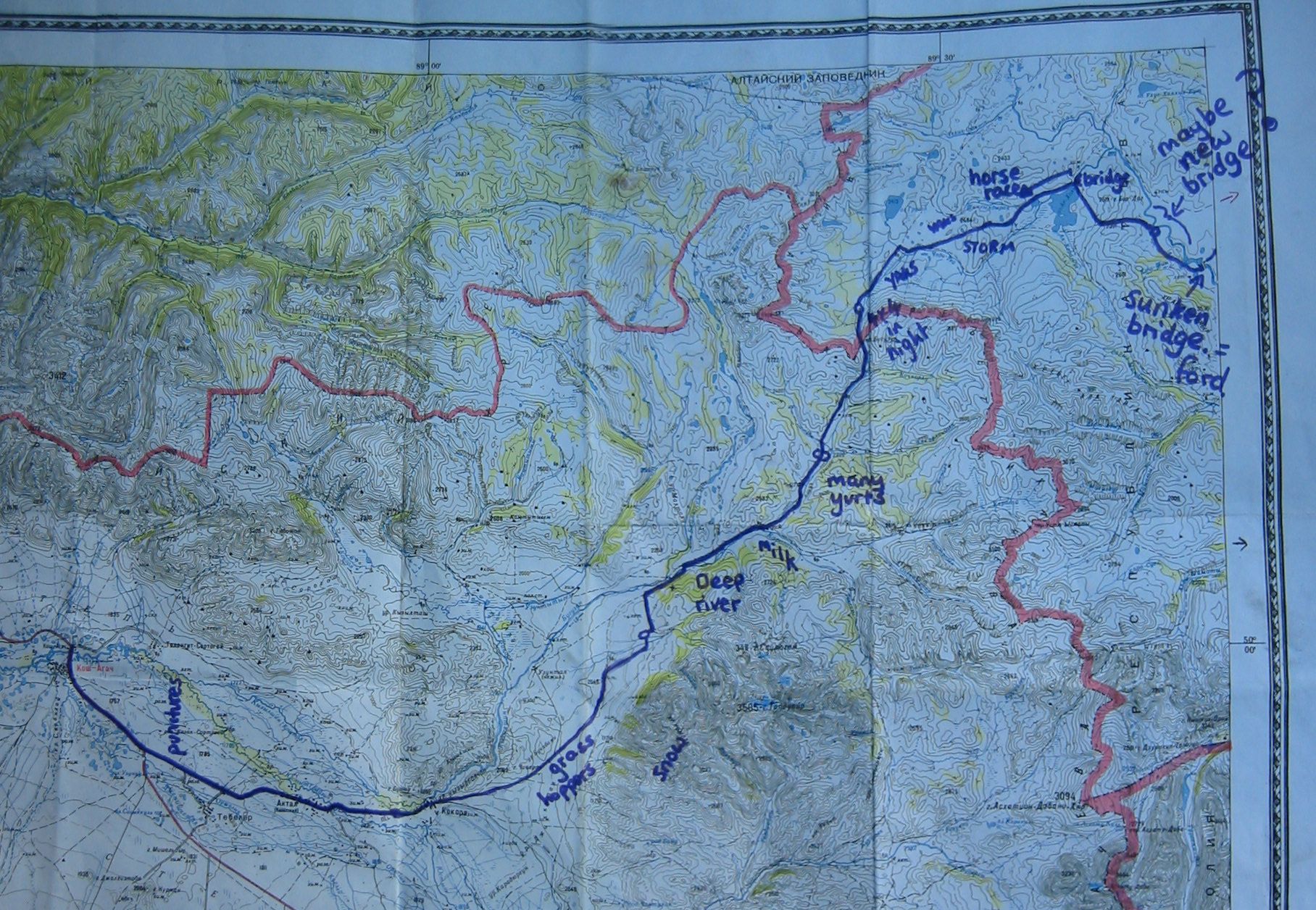
After a few kilometers the track branches and the left branches goes uphill with power lines beside it. We went right but if you go left to the village of Uzuntal you may find that there is a bridge across the river Buguzun. Going right we headed up the valley, the first water we found was about 18km from Kokorya. About 28km from Kokorya the track crosses the river (see photos on diary page). We crossed a couple of hundred meters upstream of the ford using a 6mm rope, you need a 25m length. However we watched two guys on a motorbike ford the river a little downstream of the main ford.
From there it is quite straightforward. The track stays near the river on the left (true right) bank, going into the river in one place much further upstream where the river is only a stream. The main track goes up the Buguzun pass, which is easy to push a bike up, even ride if lightly laden.
Once over the Buguzun pass follow the track down to the plateau and then east past a small round lake and over a low pass. Once on the plateau the track does not follow the Chedi-Tee river as marked on the map. From the low pass you will see a small lake with the larger Ak Hol lake beyond. Descend to the north of the small lake and follow a track around the north shore of Lake Ak Hol, there is a bridge at the north end of the lake.
If you want to go to Kyzyl Khaya go to the south end of Lake Ak Hol (give the lake a wide (1km) berth to avoid sinking into the bog) and take the track which runs south-south-east from here. We were told by a soldier in the area that there were "bad people" in Kyzyl Khaya.
From this bridge over the outlet of Lake Ak Hol take the track that runs south-east up the hillside to a pass. Then descend east to the river Mogen-Buren. There may be a bridge over this river somewhere in the next few kilometers downstream. The bridge marked on the map though has fallen in. You can ford the river fairly easily.
Once across the river head east-north-east across the steppe towards a pass in the distance. Ask someone to point out the route to Mugur Axy. There is a good track towards the pass which ends at a wooden cabin about halfway up. The track continues faintly over a series of false summits until you eventually get a view over the remote Lake Khindiktig Khol. Follow the track around the south side of the lake, sometimes right beside (or even in) the lake, sometimes climbing over bluffs. This is the dreaded "balotta" (mud) section which could be tricky in a 4WD or motorbike. If your bicycle gets stuck you know what to do!
Eventually you climb a pass (there is only one track) and get a view into the Kargu valley. The descent is steep and over 300m. Once in the valley cross the Kargu river (there was a yurt with friendly people near the crossing when we were there) and follow the track down the left side of the valley. A couple of kilometers before Mugur Axy cross the Kargu river again on a bridge and follow the track into town.
Mugur Axy has a basic hotel (diagonally opposite the police/military building) and a profusion of shops, most selling the same things. In the shops by the hotel we found cucumbers, cabbage, tinned tomatoes, sausage and dried fish. There are two roads onwards from Mugur Axy, the car road, which goes south over at least one pass, and the horse road which goes south-east down the valley from the petrol station. On a bicycle the horse road is the easier, after about 18km you will come to the properly built dirt road along which all supplies go to Mugur Axy and Kyzyl Khaya (mostly coal). It is severely bumpy and rocky, but the scenery is good and if you get fed up with it, it is very easy to hitch a lift with the many empty coal trucks heading east (make sure you tie the bike down well and pad any contact between it and the truck). If doing this route from east to west, the horse track to Mugur Axy leaves the dirt road at the foot of the steep pass, just past Km 28 (Km 128 if coming from the east).
The dirt road immediately goes up a terribly steep pass with 500m of ascent. Then gently down to a cafe at Km 55. If you are feeling brave the direct route to Ak Douvrak leaves the dirt road behind the police post by the cafe. Apparently it crosses the fast waist deep river 200 times (surely an exaggeration, but many times) and can only be done by horse or maybe small jeep, except in the winter when the river is frozen. I looked at the first ford and didn't fancy it. Then the dirt road goes over the Arzaiti Pass, on the way down which you cross a stream by a collapsed bridge. The next water is just past Sagly. Sagly apparently does have a shop or two, but also has many drunks. We didn't visit.
The dirt road joins the asphalt road from Chadan to Khandagati. The Khondergeh Pass is pretty steep but after that it is downhill all the way to Chadan. If coming from the east, the dirt road takes off almost opposite the police post, near Km 66.
We were helped with information from Igor Fedyaev of http://extreme.k2.omsknet.ru/eng who organises treking in the area.
1:200,000 scale map of Altai section of route (760k)